By: Jyotika I. Virmani and
Christina Holland
After countless
years of quietly going about its business, El Niño has
finally gotten public recognition. Planes crashing and ships
colliding in Indonesia because of smoke from massive forest
fires, hurricanes in Mexico, mud slides and flooding in California,
mass destruction of the Amazon rainforest, beaches of dead sea
lions in Chile, you get the idea. Now it seems that you can't
even go grocery shopping without being affected by El Niño!
We have begun to realize how important this climatic phenomenon
is, and how it impacts every aspect of life; from increases
in the prices of our beloved coffee and chocolate, to increases
in diseases; from decreases in gas prices, to a decrease in
the number of hurricanes hitting the eastern USA. It's worth
your while to learn about El Niño, because the odds are
that it will affect you and your students in some way, either
now or in the future.
What, you think you've
heard enough about El Niño already? We don't think so.
In fact, we are dedicating this article to that awesome phenomenon.
The Spanish-speaking world knows
that el niño means male child. Most of the
Spanish-speaking world is Christian. But what do these two facts
have to do with our climate? What we now know as El Niño,
a warming of sea surface temperatures in the eastern tropical
Pacific, occurs every 2-7 years. But once a year, around Christmastime,
there is also a smaller warming of these waters off the coast
of Peru. Peruvian fishermen were the first to call this annual
warming El Niño, in honor of the Christ Child. Catches
by Peruvian fishermen decreased during the annual El Niño,
not because it was Christmas and they were too busy celebrating,
but because the warm surface waters prevented nutrients from deeper
in the ocean reaching the surface. The fish would swim away to
colder, more nutrient-rich waters. Every few years the fishermen
noticed that the warmer waters lasted longer than a couple of
months and the warming would start much earlier in the year than
normal. This inter-annual warming of the eastern tropical Pacific
Ocean is what we now call El Niño. It is much warmer and
it covers a larger portion of the Pacific Ocean than the annual
warming trend first noted by the fishermen.
Normal
Conditions in the Pacific
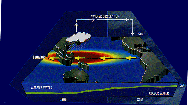 Before we understand what El Niño
is, we need to know the normal conditions in the Pacific Ocean.
The water in the west is warm (red
region). We call this region the warm pool because
it is the warmest part of the entire world's ocean surface. Warm
water evaporates, forming clouds, which leads to a lot of rain.
So with the warm pool, we get a lot of rainfall in the western
tropical Pacific. In contrast
to the warm pool region, the water in the eastern Pacific is cold
(blue region). Look at the position of the green line in the figure.
That's the thermocline - a region in the ocean where
water temperature changes rapidly over a short depth. There is
colder, nutrient-rich water below the thermocline and warmer,
nutrient-depleted water above it. Normally the thermocline is
deeper in the western equatorial Pacific than in the eastern equatorial
Pacific, so colder water is closer to the surface in the east
than in the west. The surface water is colder in the east because
the cold water under the thermocline is brought up to the surface
by a process known as upwelling (caused by the winds),
which happens mainly on the western side of continents.
Another reason the water is warmer
in the west and colder in the east is directly because of the
atmosphere. Winds tend to blow from regions with high atmospheric
pressure to areas where the atmospheric pressure is lower. We
normally have high pressure over Tahiti, in the eastern side of
the Pacific, and low pressure over Darwin, in northern Australia,
on the western side of the Pacific. Tropical winds (shown by the
yellow arrows in the figure), called the trade winds,
blow from the east to the west, pushing the warmest water to the
western tropical Pacific. The white arrows show the movement of
air in the atmosphere, known as the Walker circulation.
In the 1920's, a British meteorologist,
Sir Gilbert Walker, discovered that when the pressure is high
over Tahiti, it is low over Darwin, and vice versa. Like a see-saw.
He called the difference between these two pressures the Southern
Oscillation Index.
Before we understand what El Niño
is, we need to know the normal conditions in the Pacific Ocean.
The water in the west is warm (red
region). We call this region the warm pool because
it is the warmest part of the entire world's ocean surface. Warm
water evaporates, forming clouds, which leads to a lot of rain.
So with the warm pool, we get a lot of rainfall in the western
tropical Pacific. In contrast
to the warm pool region, the water in the eastern Pacific is cold
(blue region). Look at the position of the green line in the figure.
That's the thermocline - a region in the ocean where
water temperature changes rapidly over a short depth. There is
colder, nutrient-rich water below the thermocline and warmer,
nutrient-depleted water above it. Normally the thermocline is
deeper in the western equatorial Pacific than in the eastern equatorial
Pacific, so colder water is closer to the surface in the east
than in the west. The surface water is colder in the east because
the cold water under the thermocline is brought up to the surface
by a process known as upwelling (caused by the winds),
which happens mainly on the western side of continents.
Another reason the water is warmer
in the west and colder in the east is directly because of the
atmosphere. Winds tend to blow from regions with high atmospheric
pressure to areas where the atmospheric pressure is lower. We
normally have high pressure over Tahiti, in the eastern side of
the Pacific, and low pressure over Darwin, in northern Australia,
on the western side of the Pacific. Tropical winds (shown by the
yellow arrows in the figure), called the trade winds,
blow from the east to the west, pushing the warmest water to the
western tropical Pacific. The white arrows show the movement of
air in the atmosphere, known as the Walker circulation.
In the 1920's, a British meteorologist,
Sir Gilbert Walker, discovered that when the pressure is high
over Tahiti, it is low over Darwin, and vice versa. Like a see-saw.
He called the difference between these two pressures the Southern
Oscillation Index. El
Niño Conditions
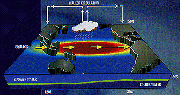
In an El Niño
year, the conditions change. The atmospheric pressure in the western
Pacific, over Darwin, gets higher, but over Tahiti it gets lower
- Walker's see-saw flips. Because
the atmospheric pressure patterns have changed, the trade winds
tend to die down or even reverse direction and blow from west
to east (the yellow arrows in the figure). Now the trade winds
no longer push warmer water to the west, so the warm water is
allowed to move eastward, bringing its associated rainfall. This
is one reason why the eastern Pacific warms up. The other reason
is that the thermocline is now deeper than usual in the eastern
Pacific, so the cold water underneath it is deeper. This makes
it harder to bring cold, nutrient-rich water to the surface by
upwelling.
La
Niña Conditions
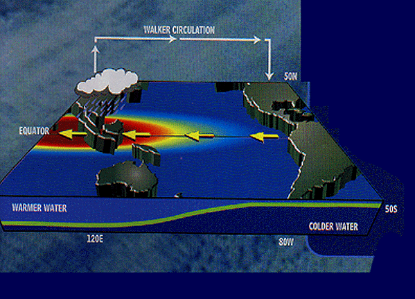
A third
condition in which the Pacific ocean-atmosphere system can exist
is the reverse of El Niño. In keeping with the naming convention
established by the Peruvian fishermen, scientists have called
it La Niña, a female child. It is not as well known as
its bigger brother, El Niño, because the changes in climate
associated with La Nina are not as severe. During a La Niña
event, the high pressure over Tahiti becomes higher than average,
and the low pressure over Darwin is lower than average. This leads
to extremely strong trade winds blowing from east to west across
the tropical Pacific. These winds move the warm pool waters and
associated rainfall even further west, and the eastern Pacific
gets colder than usual.
El Niños &
La Niñas - Past & Present
Evidence of El Niño
and La Niña events in the Pacific can be seen in many proxy
records, including tree rings, ice cores, and corals. El
Niño and La Niña events vary in size, intensity
and duration. The last major El Niño (before 1997/98) was
the 1982/83 El Niño, which cost 2,000 lives and between
$8-$13 billion of damage worldwide. Don't worry, they are not
all as severe as that one. In fact, between the 1982/83 and the
1997/98 El Niños, we have had at least two others. Since
the 1982/83 El Niño though, scientists have focused on
how we can predict these events so that governments can have enough
warning to make contingency plans. In 1985, 79 buoys were deployed
in the Pacific to continuously monitor the state of the ocean
and the atmosphere. Computer prediction models have also been
developed to try and predict these events. Currently we can predict
an El Niño or La Niña about one year before it reaches
maximum intensity (which is usually in November or December).
The work done by these scientists paid off this past year. The
1997/98 El Niño event is the largest one this century in
terms of its intensity but because we knew so much more about
it than in the past, people have had time to prepare. So
now that you know all about the El Niño - Southern Oscillation
(ENSO) system, as we scientists like to call it, you are probably
wondering what is going to happen during the next year? Well,
observations from the Pacific show that the 1997/98 El Niño
has died down, and computer models predict that we will move into
a La Niña phase next. Usually, in a La Niña year
there are more hurricanes on the eastern seaboard of the US and
possible drought conditions in the mid-western states. Remember,
though, that these are still predictions. Mother Nature can throw
us a curveball from time to time.
Some Global El Niño
Effects Droughts in Australia, eastern Asia
and eastern South American countries: Forest fires, including
massive destruction of the Amazonian rainforest; Bad crop harvests,
including coffee beans and cocoa, leading to increased prices;
Famine; Destruction of natural habitats
-
Floods in western South American countries
and eastern African countries: Famine; Increases
in tropical and infectious diseases such as malaria and cholera;
Destruction of natural habitats Changing sea temperatures:
Decrease in fish population off South America's western coast
leads to massive animal mortality (especially sea lions and
birds) and collapse of fishery-dependent economies (for example,
Peru); Coral reef bleaching; Increased typhoon activity in
the Pacific affecting Central America; Decreased hurricane
activity in the Atlantic
Some El Niño
Effects in the United States Floods and
mud slides in the western states, especially California
Wet winters / floods in the southeastern states, especially
Gulf states
Decreased hurricanes in the Gulf states and eastern seaboard
states
Increased hurricanes in the southwestern states, such as Hawaii
Mild winters in the northeastern states
Increased diseases in the southern states
|
