Themes and Activities
Applied Hydrography
The National Oceanic and Atmospheric Administration Office of Coast Survey Strategic Plan for the next five years includes expanding and strengthening capabilities to collect geospatial data in the nearshore and continental shelf regions. NOAA’s Office of Coast Survey will collaborate with other federal agencies and contractors to increase ocean and coastal mapping in United States waters and update nautical charts containing historical data (National Oceanic and Atmospheric Administration Office of Coast Survey, 2023).
These objectives are directly related to the National Strategy for Mapping Exploring and Characterizing the United States Exclusive Economic Zone. This strategy outlines a plan to explore and characterize priority areas identified in the Exclusive Economic Zone using characteristics such as depth, sediment composition and sediment distribution (Ocean Science and Technology Subcommittee, 2020).
Learn how COMIT is contributing to these efforts in the projects outlined below:

Dr. Stephan O’Brien speaking to GOMCON 2024 attendees about COMIT’s backscatter calibration site in Tampa Bay
Backscatter Relative Calibration Sites
Currently, it is challenging to compare multibeam backscatter acquired during independent surveys that use different multibeam sonars. Calibrated multibeam backscatter enables the backscatter acquired from similar multibeam sensors to be merged into a mosaic for further evaluation and analysis. COMIT has been working to identify one or more locations on the West Florida shelf near Tampa Bay that would be suitable for use as a relative calibration site for multibeam backscatter.
Preliminary data was collected from 6 sites in the fall of 2023 and 1-2 will be re-sampled this fall and winter (2024). One of these sites will then be selected as the Tampa Bay multibeam backscatter calibration site – allowing partners such as NOAA National Ocean Service, the U.S. Coast Guard, U.S. Geological Survey (USGS), the Florida Fish & Wildlife Conservation Commission and Fish and Wildlife Research Institute to calibrate their respective sonar systems for more consistent and accurate backscatter data collection.
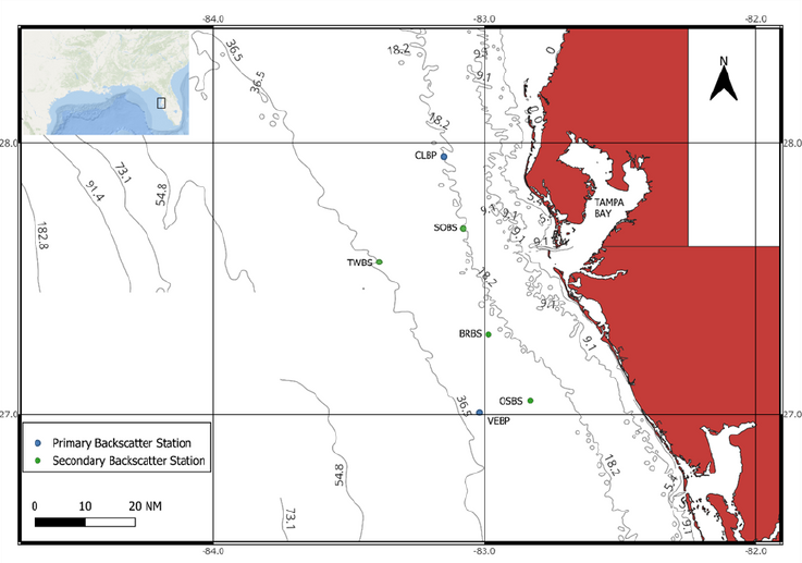
Proposed backscatter calibration sites in Tampa Bay
Methods for Mapping and Characterizing Seafloor Habitats on the West Florida Shelf and Beyond
The NOAA Office of Coast Survey is using high-resolution multibeam bathymetry and backscatter data to map the nearshore region and understand marine habitats. This information is crucial for managing marine resources, such as fish populations.
COMIT researchers have developed methods to link video observations to multibeam data to create habitat maps and analyze fish distribution. Software was also created to process and analyze bathymetry and backscatter data, which is available on Github here: https://ailich.github.io/MultiscaleDTM/
While backscatter is important for identifying substrate composition, it’s often uncalibrated, making it difficult to use in models across different surveys. Calibration of multibeam backscatter is an active area of research within COMIT. Having calibrated backscatter can enable using backscatter in models over larger and non-overlapping areas and more generalizable models ultimately improving the consistency and usability of backscatter data.
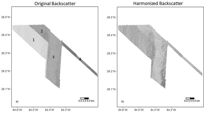
Original backscatter surfaces from four different surveys (a), and harmonized backscatter (b)
Mining Multibeam Transit Data for Deep Ocean Polymetallic Nodules, A Case Study in the SE Pacific Ocean
The Exclusive Economic Zone contains critical minerals such as polymetallic nodules, mineral-rich formations on the seafloor that are estimated to be worth billions of dollars. Mapping this region will complement future plans to mine the polymetallic nodules located on the outer continental shelf and multibeam backscatter data is required to identify polymetallic nodules on the seafloor and generate habitat maps.
Multibeam bathymetry and backscatter data, along with auxiliary data suggest an area of seafloor near the Foundation Seamount chain in the southern Pacific Ocean. Using multibeam data collected in 1997, strong backscatter signals combined with other factors like water depth and seafloor slope, indicated the potential presence of polymetallic nodules.
The study developed a method to identify such areas by comparing backscatter data with specific environmental criteria. For the examined case study, evidence from a single multibeam transit indicates an approximately 3,000 km2 area covered in polymetallic nodules lying in about 4,100 m of water. Research has not considered whether the data may represent a smaller component of a larger uncharted nodule occurrence. These methods could help prioritize future exploration activities including transit planning to or from focused survey areas, and can assist scientists and regulators in estimating marine ecological and mineral resources.
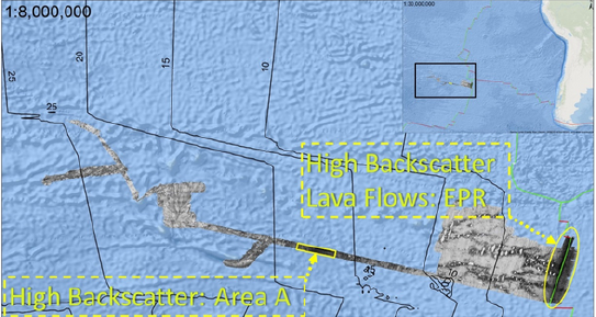
Transit dataset in regional context. A low 8-bit backscatter pixel value corresponds with
higher backscatter intensity (USGS, 2021; Müller et al., 2019; Blais et al., 2002).
Hurricane Idalia
COMIT researchers worked with the American Shore and Beach Preservation Association (ASBPA) to obtain a Hohonu water level sensor at a discounted rate. The ASBPA received a grant from the Southeast Coastal Ocean Observing Regional Association (SECOORA) to join a network of coastal communities in the Southeast to install low-cost water level sensors that collect real-time data and provide more accurate predictions in locations where there are no NOAA tide gauges nearby. The sensor was installed at John’s Pass in Madeira Beach, Florida, and in the summer of 2022 during Hurricane Ian, the sensor captured drastically low water levels from sustained offshore winds. In the summer of 2023, high winds and water levels damaged the sensor, but not before it transmitted peak water levels. Impacts from Hurricane Idalia in the Tampa Bay region were significant with water levels at least four feet over tidal forecast values occurring in late morning of August 30, 2023.
The Hohonu water level sensor was reinstalled in early 2024. Historical readings can be accessed here: https://dashboard.hohonu.io/map-page/2895b6e4-5c50-4ef4-8c4f-611ad8e0a772/John’sPass, however, the 2024 hurricane season has left the sensor inoperable once again.
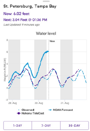
Screenshot of water level from Hohonu sensor at John’s Pass during Idalia in late August 2023.