Seafloor Mapping at CMS
A brief History
Seafloor Mapping at USF’s College of Marine Science: a glimpse into the past with an eye towards the future
Seafloor Mapping at CMS
Visit the full photo gallery and list of publications related to this article.
For most people, St. Petersburg, Florida quickly conjures up images of pristine coastline, sunshine, and a vibrant downtown scene. The ‘Burg is less well known for its rich marine science history, but is in fact now home to the largest marine science complex in the Southeast United States. This hub includes the USF College of Marine Science (USF CMS), the USGS St. Petersburg Coastal and Marine Science Center, the NOAA National Marine Fisheries Service, the Fish and Wildlife Research Institute, the Florida Institute of Oceanography, the Tampa Bay Estuary Program, the US Coast Guard, as well as the City of St Petersburg’s administration and its Innovation District.
The story of the USF CMS, which is 54 years old this year, continues to add new chapters — most recently with the creation of the Center for Ocean Mapping and Innovative Technologies (COMIT). Established as a five-year cooperative agreement with NOAA, COMIT is now part of a rich, 40-year history in the College’s research and exploration of the seafloor throughout the Gulf of Mexico and beyond.
Foundations of seafloor mapping at CMS
Seafloor mapping at CMS traces its history to 1979 when Al Hine, PhD, joined the faculty after a postdoctoral position at the University of North Carolina – Chapel Hill. About a decade later, Stan Locker, PhD, came to USF CMS in 1987 as a postdoctoral scholar. Hine and Locker already had a good working relationship prior to their concurrent appointments at USF, but it was during their CMS tenure that the partnership really took off. Together they developed numerous projects resulting in many publications, many of which highlight their collaborative research with seismic reflection. In time, Hine and Locker began incorporating sidescan sonar into their survey methods which led to the West-Central Florida Coastal Studies Project (1993 – 2000) in partnership with the United States Geological Survey (USGS) and Eckerd College, also in St. Petersburg. It was through this work that the project’s scientists collected data along sonar transects from Anclote Key to Venice Beach. Their analyses led to a better understanding of the sedimentation processes that occur near barrier islands on Florida’s Gulf coast, as well as how Florida’s western coastline has changed over time. Key to the success of this work was the partnership between USF CMS and USGS, which formed in 1987 when the USGS designated the USF CMS as a National Center for Coastal Geology. The USGS Coastal and Marine Science Center then moved into downtown St. Petersburg in 1988 and the rest, as they say, is history. A sidescan sonar towfish is deployed during one of the USGS-USF CMS Anclote Key to Venice Beach mapping expeditions. [Image credit: Al Hine]]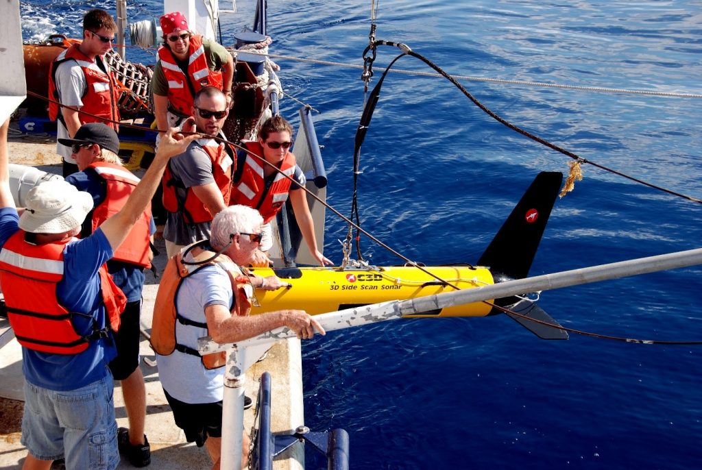
Within a few years of West-Central Florida Coastal Studies Project’s inception, David Naar, PhD, joined CMS. It was around this time that multibeam bathymetry as a mapping tool became a larger focus among the geological oceanography faculty at the College. It was also the type of work that Naar had cut his teeth on during his graduate studies at the Scripps Institution of Oceanography starting in 1982.
“Bathymetry is one of the most fundamental tools of understanding our planet,” Naar says, a sentiment echoed by Hine. “When you can map first, then you can start to ask more sophisticated questions because you’ve never seen it before. We’ve learned an enormous amount, but at the same time there’s an enormous amount left to learn,” Hine said.
This was well-exemplified in the mid-2000s when USF CMS and the USGS mapped a mesophotic coral reef off the southwest Florida coast called Pulley Ridge, now designated as a Habitat Area of Particular Concern (or HAPC) by NOAA. Though it was peripherally known that hardbottom existed in this area since the 1950s, it took over five decades before the full extent of the area was mapped. Subsequent underwater surveys with remotely operated vehicles (ROVs) and submersibles showed that it possessed incredibly diverse coral and fish communities. Not only was this a major find, in and of itself, but this reef was also the deepest known photosynthetic reef at that time.
Stanley Locker, PhD, teaches graduate students about sidescan sonar data collection during a research expedition.
Seafloor Mapping takes time and money – and disasters?
The 1960s were a hey-day of exploratory science as ship time and associated research funds were more abundant than the pool of scientists needed to direct and use them. Over time, however, these funding sources began to dwindle, and exploratory fieldwork declined in favor of hypothesis-driven research. “Scientists working on seafloor mapping must now be more strategic in where their efforts are concentrated due to limited resources and/or find a research question to support their mapping work via a problem-driven funding institution,” Hine said. Convincing funding sources (including state and federal legislatures) that seafloor mapping should be a priority hasn’t always been easy.
“Funding availability tends to come with disasters, unfortunately, and it’s not as common for people to take the preventative approach,” Hine said.
This is precisely what occurred for COMIT’s immediate predecessor, the Continental Shelf Characterization, Assessment, and Mapping Project (C-SCAMP). The C-SCAMP group was supported by the National Fish and Wildlife Foundation from 2015 to 2020 through a grant established via penalty funds assessed after the Deepwater Horizon oil spill in 2010. During this project, C-SCAMP’s team was able to collect an additional 2,350 km2 of high resolution multibeam bathymetry on the West Florida Shelf and associated baseline habitat and reef fish population information via a towed camera platform called the Camera-Based Assessment Survey System (C-BASS) developed by USF CMS engineers.
In the absence of a continuous, coordinated approach, progress to better understand our oceans by mapping them can be disjointed and slow. Naar highlights the Florida Middle Grounds project he led as an example; this 1,200 km2 Habitat Area of Particular Concern took several funding rounds and six years of fieldwork to complete (1999-2005). Despite decades of effort on the parts of Naar, the USGS, and USF College of Marine Science’s C-SCAMP group, the Exclusive Economic Zone (EEZ) of Florida’s Gulf Coast remains only 6% mapped at high-resolution (10×10 m grid or finer).
Unified map of substrate at 10 m resolution delineating rocky reef (red) from sandy habitats (yellow) across all available high resolution multibeam for the north eastern West Florida Shelf created using a semi-automated statistical classifier that was trained using multibeam bathymetry and towed camera (C-BASS) ground-truth observations. [Image credit: Alex Ilich, Continental Shelf Characterization, Assessment and Mapping Project]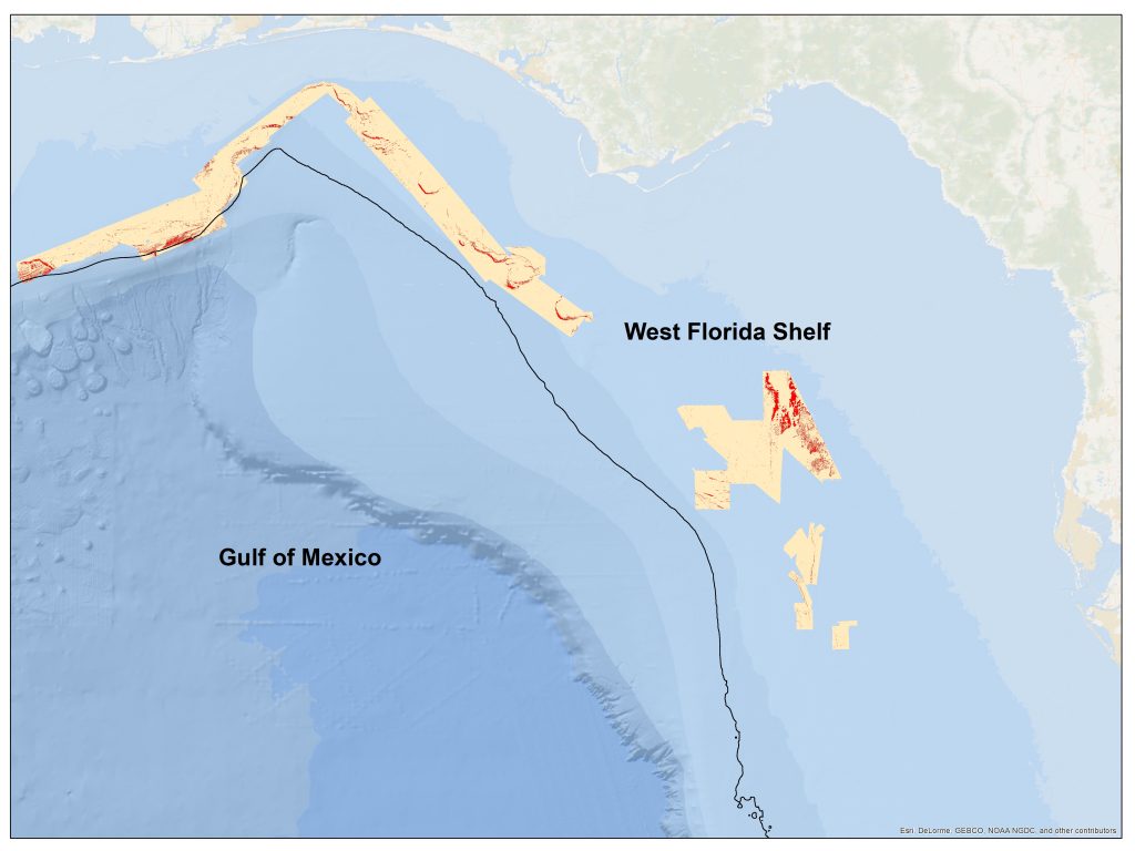
Yet the need for more mapping work is obvious. We were reminded of it when the Deepwater Horizon oil spill occurred in 2010 and Florida narrowly avoided significant impact from surface and sunken oil to the same extents as Louisiana, Mississippi, and Alabama; and it remains pressing despite the recent extension of the eastern Gulf of Mexico’s moratorium on oil and gas exploration to 2032 as leases continue to multiply near the western moratorium boundary. The benefits of seafloor mapping also support the rise of the Blue Economy; from the expansion of offshore aquaculture and wind energy operations and the need for improved fisheries management – particularly in regard to habitat mapping and assessment, knowing more about the seafloor can benefit a wide array of stakeholders.
Mapping the world’s oceans: an achievable goal
Even in the face of considerable logistical, financial, and prioritization challenges, there are strong examples of seafloor mapping being made a priority in the United States; this is perhaps best demonstrated by the California Seafloor Mapping Program (CSMP), which began in 2007. According to Naar, California was so successful in their endeavors as a result of coordinated and cooperative efforts among numerous state, federal, and private funding and research agencies.
The good news is that a comprehensive map of the Gulf of Mexico’s, and in fact the United States’, exclusive economic zone (EEZ; 0-200 miles offshore) is not an insurmountable goal – it’s just going to take more organization. This has even been designated as a priority by the U.S. Federal Government.
“Because this is expensive work, there is a need to get all the stakeholders and funding agencies on the same page,” said Locker, “and this seems to be starting to happen.”
In Florida, there’s the added challenge of having considerably more coastline than most other states, as well as a state maritime boundary in the Gulf of Mexico more than three times farther offshore than most states. In fact, Florida has more marine waters under its jurisdiction than any other state aside from Alaska.
Despite the challenges, state and federal agencies, academic institutions, and private mapping firms have stepped up in a major way to form the Florida Coastal Mapping Program (FCMaP), an analogous entity to California’s CSMP. The FCMaP was organized by the U.S. Geological Survey, Florida Institute of Oceanography, Florida Fish and Wildlife Research Institute, and Florida Department of Environmental Protection in 2017. Since then, their stakeholder base has expanded and FCMaP has been working to organize Florida’s inshore (0-20 meters) and offshore (20 – 200 meters) mapping efforts with a goal of having Florida’s EEZ completely mapped by 2028.
Current state and regional-based efforts to map their respective EEZ’s are being organized during an unprecedented time as they are bolstered by significant domestic and international initiatives to map the world’s oceans. In the U.S., this is began with the White House’s memorandum on ocean mapping issued in late-2019 which established national priorities for seafloor mapping and ocean exploration. This has led to the formation of the National Ocean Mapping, Exploration, and Characterization strategy (NOMEC) released by federal agencies in June 2020. Since then, things have continued to move fast: in November 2020, NOAA sought public input on the approaches to ocean mapping outlined in NOMEC and in January 2021, a formal implementation plan was announced. On a global scale, formation of the Seabed 2030 initiative, spearheaded by the General Bathymetric Chart of the Oceans (GEBCO) and Nippon Foundation, has resulted in numerous collaborative efforts. The goals of Seabed 2030 are echoed in COMIT’s Mission Statement and the initiative is a key driver of the Center’s research priorities.
Ground-breaking, rapid technological developments are paving the way
As national and international priorities in ocean mapping have continue to evolve, there’s been a parallel increase in the pace of technological development. Seafloor mapping and exploration using traditional approaches (ship-mounted sonars) has been rapidly shifting towards using autonomous vehicles (programmable sea-going robots) with miniaturized sonars to “force-multiply” what could be done with ship-based mapping alone. This was highlighted in December 2015 when the Shell Ocean Discovery XPRIZE competition, led by USF CMS alum, Jyotika Virmani, PhD, was announced during the American Geophysical Union’s annual conference and challenged participants to develop transformative deep sea mapping technology. With a $7million total prize, the incentive to compete was considerable. Ultimately, the GEBCO-NF Alumni Team was announced as the winner in 2019. Their unmanned surface vehicle (USV), called Sea-Kit, could deploy and recover an autonomous underwater vehicle (AUV) equipped with a multibeam echosounder, all on its own (sans humans) which was a first in ocean mapping. Seafloor mapping technological development has also resulted in some important ancillary effects.
“When survey platforms such as autonomous surface and underwater vehicles [ASVs & AUVs] are used, not only do they reduce operating costs by using less fuel, but lower fuel usage also lessens our carbon footprint to do this type of work,” says Virmani, now Executive Director of the Schmidt Ocean Institute.
Locker also points out that another notable effect of advancements in seafloor mapping technology is that these products have become more widely available to and usable by non-experts. This means that many different disciplines have been afforded a seat at the seafloor mapping table which ultimately expands total ocean exploration and mapping efforts, and facilitates new avenues for geological and biological research.
The market for seafloor mapping-related equipment and products is still relatively young but is now experiencing considerable growth – there are a few “big players” that have been around for years, but we’re now seeing several offshoot competitors enter the market. These companies are continuing to push the envelope and meet the mapping community’s needs which will help reach these national and international goals of mapping the world’s oceans by the end of the next decade, said Matthew Hommeyer, COMIT’s Field & Technical Operations Manager.
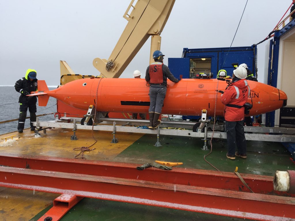
A Kongsberg Hugin AUV that COMIT co-PI, Alistair Graham, PhD, worked with in 2019. The AUV was outfitted with sidescan and multibeam sonars, the latter of which can be seen forward of the vehicle just behind the nose cone. The multibeam sonar could also be mounted for upward looking in situations where the vehicle is working under floating ice. [Image credit: Linda Welzenbach, outreach staff member on the Thwaites project].
COMIT: a new era for seafloor mapping at the CMS
The technology boom in ocean exploration highlights a need that COMIT is dedicated to helping fill. With so many options in products related to seafloor mapping now available, Hommeyer says that selecting the right tool for the right job can be akin to trying to drink from a fire hose.
The University of New Hampshire’s Center for Coastal and Ocean Mapping (CCOM), funded by NOAA since 1999, has considerable experience with a wide array of the sensors, technology, and software on the market – but no one entity has tested, used, and reviewed them all. Part of COMIT’s mission is to work with groups like CCOM to provide decision tools to determine what combinations of different technologies and products are best for specific mapping tasks while also balancing productivity with operating costs.
COMIT’s broad goals includes the following:
- Extending mapping capabilities and promote collaboration among various NOAA line offices (e.g. National Ocean Service, National Weather Service, National Marine Fisheries Service, Oceanic and Atmospheric Research, National Centers for Environmental Information, and Office of Marine and Aviation Operations).
- Driving technological advancement and efficiency to address priorities outlined in the National Ocean Mapping, Exploration, and Characterization (NOMEC) of the U.S. EEZ Strategic Plan through the Center’s research projects.
- Enhancing local and national capabilities and partnerships for seafloor mapping in support of Seabed 2030.
- Developing academic programs, including certificates, additional courses, and professional development opportunities to train the next generation of seafloor mapping specialists.
“The goals of COMIT are to both serve the interests of NOAA and other agencies in developing and enhancing the tools and techniques for ocean mapping, and to enhance training opportunities in these fields. By doing so we provide new insights into how oceans change over time and how they respond to human activities,” says Steven Murawski, PhD, Principal Investigator of COMIT. “These are lofty goals which can only be accomplished through vital partnerships between the federal and state agencies, academic institutions and private sectors.”
Many oceanographers will tell you that “We know more about the moon than we do about the bottom of the ocean.” And this is true. As of mid-2020, the entire surface of the moon has been mapped, compared to the general consensus for the world’s oceans which says that just under 20% has been revealed. And in fact, according to Larry Mayer, PhD and his colleagues at Seabed 2030 – 93% of the global seafloor deeper than 200 m could be mapped for the same cost as one Mars mission (approximately $3billion USD).
With so much current interest in seafloor mapping, the next decade should prove to be a second “golden age” in mapping the world’s oceans. And COMIT is ready to do its part in this grand endeavor.
To stay up-to-date on COMIT’s contributions to seafloor mapping and ocean exploration, please visit our News page and follow us on LinkedIn. A more detailed overview of the Center can be found here.
The author would like to thank Al Hine, David Naar, and Stanley Locker for taking the time to talk about their experiences which provided the foundations for this article. Many thanks also to Jyotika Virmani and Matthew Hommeyer for discussing their perspectives on the changing technological landscape in ocean exploration, as well as Kristen Kusek for providing much appreciated guidance, feedback, and red pen during the development of this article.