Center for Ocean Mapping & Innovative Technologies
A NOAA-funded mapping center working on newer, faster, more efficient approaches to seafloor mapping and improving the response to and identification of coastal hazards
PROGRAM FOCUS AREAS
Click on the icons below to learn more.
Uncrewed Systems
Improving the efficiency of seafloor mapping efforts via advanced technology and processing algorithms.
Geodetic Observations
Developing tools for high precision measurements of the seafloor in coastal zones.
Applied Hydrography
Increasing capacity to rapidly respond to coastal impacts and changes.
Forecasting
Resolving complexity of spatial and temporal scales for hydrodynamic modeling in nearshore environments.
Professional Development
Capacity building through hosted training modules, graduate coursework, and internships.
Outreach
Products and media for variety of different audiences plus the development of a crowdsourced bathymetry program.
News Feed
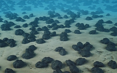
USF College of Marine Science Becomes Home for International Marine Minerals Society (IMMS)
The USF College of Marine Science in St. Petersburg, FL announced today that it is the new home for the International Marine Minerals Society (IMMS). See the full article here!
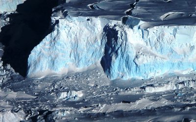
USF Scientist Helps Measure a Rapidly Melting Glacier
At the end of January, USF CMS associate professor Dr. Alastair Graham, departed on the US icebreaker Nathanial Palmer for the Amundsen Sea, home to the so-called “Doomsday Glacier” called the Thwaites Glacier. Thwaites, the size of Florida, has been in the news...