 DISCLAIMER: The Continental Shelf Characterization, Assessment and Mapping Project (C-SCAMP) requests that it be referenced as the originator of this dataset in any future products or research derived from these data. These data are scientific in nature and should not be used for navigation or any purposes relating to safety at sea. As such, the Continental Shelf Characterization, Assessment and Mapping Project (C-SCAMP) will not be held accountable for any injury, loss, or damage resulting from their misuse.
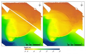
Above: Before and after of the area that was opportunistically mapped by C-SCAMP in April 2016. The data in the lower left
are from USGS and the dataset in the upper right was collected by David Naar at the University of South Florida.
Below you can download multibeam bathymetry data for the gap that exists between the datasets covering the Madison-Swanson MPA. The file types available are a .kmz and GeoTIFF, both of which can be imported into GIS programs.
Note: for the GeoTIFF to work properly, you must download the XML file as well by right-clicking the image and saving the file.

